THE BATTLE AND BATTLEFIELD.
I.
 o Edge Hill from Banbury a good road trends gradually up hill nearly the whole way. It rises from the 300 foot level of the Cherwell Vale to 720 at the highest ground of the ridge of the hill
 . At a distance of eight miles to the North-West is the edge or escarpment of high ground bounded on the East side by the vale of a tributary of the Cherwell,
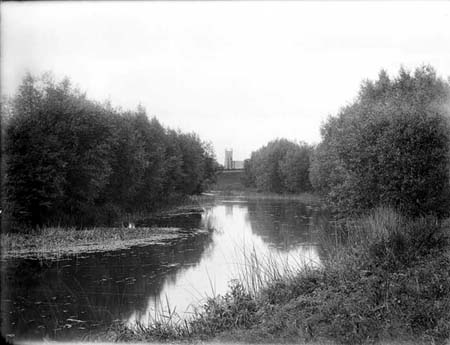 and on the North and West by the plain drained by the tributaries of the Avon. From Warmington, six miles from Banbury, North-Westwards to the point marked on the Ordnance Map as Knowle End,
 and thence South-Westwards to the Sun Rising, once the site of a hostelry on the Banbury and Stratford-on-Avon coach road, the edge makes a right angle with the apex at Knowle End.
a fine fourteenth century Church stands high above the rock of the roadway. There is the first record of the battle—a simple headstone to the right of the path to the South porch telling how one Captain Alexander Gourdin had died on October 24th, 1642, the day after the fight
. From the church-yard long flights of steps lead to the roadway and village below, where the house tops show through the foliage of the apple orchards in which they are partly hidden. Across the vale, three miles to the North, is the range of the Burton Dassett Hills, an outlier of the Edge Hill range. The Windmill Hill
From the church-yard long flights of steps lead to the roadway and village below, where the house tops show through the foliage of the apple orchards in which they are partly hidden. Across the vale, three miles to the North, is the range of the Burton Dassett Hills, an outlier of the Edge Hill range. The Windmill Hill,  the most distant, bears the Beacon House; the square tower of Burton Dassett Church
1c6vg~~60_12.JPG)
the most distant, bears the Beacon House; the square tower of Burton Dassett Church may be seen amongst the elms on the lower slopes of Church Hill; Bitham Hill appears in the foreground of the range with the pretty spire and village of Avon Dassett close at hand.
Westward of Warmington Church runs Camp Lane. It winds along the ridge, and commands wide views of the plain lands. A beautiful field path springs from the South side of the lane leading through the village of Ratley to the Round House and Ratley Grange. Facing Southwards
, one looks upon an equally pleasant
,
one looks upon an equally pleasantthough more circumscribed view—the vale of Hornton. The Arlescot Woods clothe the Northern slopes, and the Manor House rests amongst the fine trees below. The terraced fields of 
Adsum
Hollow are three miles down vale Southward, and Nadbury Camp, supposedly a Romano-british remain, is but a remnant of similar natural terracing on the South side of the Camp Lane above Arlescot
Adsum
Hollow are three miles down vale Southward, and Nadbury Camp, supposedly a Romano-british remain, is but a remnant of similar natural terracing on the South side of the Camp Lane above Arlescot
.
At Knowle End, above where the road to Kineton plunges steeply down hill, is the first point of the battle ground and the commencement, strictly speaking, of Edge Hill. A short distance down the Kineton Road, a pathway on the right leads under overspreading beech and oak trees for some distance along the crest of the Knoll, whence a good side view of the hill may be got. The gate on the opposite side of the Kineton Road opens to a path through the Radway Woods
, and from it, where the foliage is less dense a prospect opens of many wide leagues of fair midland country—a veritable patchwork of field and hedgerow. The furze below covers in part Bullet Hill, the last stand of the Royalists on the battle ground. The road from Kineton as well as the footway through the woods leads to Edge Hill Tower, or Round House. Covering the steep hill sides are beech, elm, chestnut
and lime trees of exceptionally fine growth and a wealth of common wild flowers. The Tower or Round House is an inn, which, with a modern-antique ruin, makes as it were a landscape gardening adjunct to Radway Grange lying in the park below. From its upper room is obtained a fine view of the country. It is an octagonal tower, and was erected with artificial ruins in 1750 to mark the spot where the King’s Standard was displayed before the Royalist army descended into the plain to give battle. The village of Radway rests amongst the elms near the foot of the hill, the church spire being one of the prominent objects of the foreground. Kineton lies about four miles directly to the North, beyond which Warwick Castle may be sometimes descried, or the yet more distant spires of Coventry. Some distance from the Burton hills the smoke of the Harbury lime works drifts across the landscape. The farms Battledon and Thistledon, about midway between Radway and Kineton, marked by the coppices which almost hide the homesteads, are noted from the fact of so much of the fight having revolved round them.

The footway to the Sun Rising, 1½ miles S.W. of the Round House, follows the hill side, and though still pleasantly wooded, soon gets clear[Pg 5] of that heavy growth of foliage which has hitherto shut out so much of the view. The eye ranges over the flat Warwickshire plain in front, to the hills of Gloucestershire and Worcestershire on the West and the North-West. The North-Eastern outliers of the Cotteswolds, the hills of Ebrington and Ilmington, are the nearest in prominence Westwards, beyond which a clear day will allow even the distant slopes of the Malverns to be seen. The Bromsgrove, Clent and Clee hills fringe the North-West horizon, and sometimes the Wrekin is said to appear “like a thin cloud” far away.
At the point where the pathway enters the Stratford-on-Avon road stands Edge Hill House (the Sun Rising) wherein years ago were some curious relics of the fight: breast-plates, swords, matchlocks, and a sword supposed on the evidence of emblems in its decoration to have belonged to the Earl Lindsay, who commanded the royalists forces prior to the battle, and who received his death wound in the fight
Lord Lindsey was shot through the thigh bone, and fell. He was instantly surrounded by the rebels on horseback; but his son, Lord Willoughby, seeing his danger, flung himself alone among the enemy, and forcing his way forward, raised his father in his arms thinking of nothing else, and unheeding his own peril. The throng of enemy around called to him to surrender, and, hastily giving up his sword, he carried the Earl into the nearest shed, and laid him on a heap of straw, vainly striving to staunch the blood.
It was a bitterly cold night, and the frosty wind came howling through the darkness. Whether the battle were won or lost, the father and son knew not, and the guard who watched them knew as little. Lord Lindsey himself murmured, "If it please God I should survive, I never will fight in the same field with boys again!"–no doubt deeming that young Rupert had wrought all the mischief. His thoughts were all on the cause, his son's all on him. It proved impossible to stop his wounds bleeding and gradually the old man's strength ebbed away.
Toward midnight the Earl's old comrade Essex had time to understand his condition, and sent some officers to enquire for him, and promise speedy surgical attendance. Lindsey was still full of spirit, and spoke to them so strongly of their broken faith, and of the sin of disloyalty and rebellion, that they slunk away one by one out of the hut, and dissuaded Essex from coming himself to see his old friend, as he had intended. The surgeon, however, arrived, but too late, Lindsey was already so much exhausted by cold and loss of blood, that he died early in the morning of the 24 October 1642. His son, despite King Charles' best efforts to obtain his exchange, remained a prisoner of the Parliamentary side for about a year.
Lord Lindsey should not be confused with Ludovic Lindsay, 16th Earl of Crawford who also fought for the King at the Battle of Edgehill.
.
In a fir coppice about 200 or 300 yards to the South of the house, the figure of a red horse roughly cut in the turf of the hill side might formerly be seen. Dugdale gives the following account of it: “Within the Precinct of that Manour in Tysoe, now belonging to the E. of
Northampton (but antiently to the Family of Stafford, as I have shewed) there is cut upon the side of Edg-Hill the Proportion of a Horse, in a very large Forme; which by Reason of the ruddy Colour of the Earth, is called The Red Horse, and gives Denomination to that fruitfull and pleasant Countrey thereabouts, commonly called The Vale of Red Horse. The Trenches of which Ground, where the Shape of the said Horse is so cut out, being yearly scoured by a Freeholder in this Lordship, who holds certain Lands there by that service.” There is a tradition quoted by Beesley of its having been cut to commemorate the slaughter of a chieftain’s horse at the battle of Towton, in 1461, the chieftain preferring to share the perils of the fight with his followers.
No comments:
Post a Comment